Muang Sema is certainly not a well-known site among travellers. Like most of the other major Dvaravati sites, it isn’t even mentioned in the Lonely Planet guidebook. The publishers of that traveller’s ‘bible’ seem utterly unaware of Thailand’s history before the Sukothai era. It has been visited by a few plucky bikers and bloggers, who have raised its profile, at least a little, on the Internet. But they were not particularly excited about what they had seen either. There was none of the soaring architecture which made Khmer temples such as Phimai an easier sell to backpackers, so the site had not made devout converts of the people who had taken the trouble to visit it. Nonetheless, it had remained somewhere that I wanted to see, if only for the reason that it contained the word sema, which had lent itself to the hundreds and hundreds of bai sema– the intriguing boundary markers which are one of the unique cultural attractions of the Isaan plateau. So my visit to Muang Sema was not taken in the hope of seeing glorious remains, but rather in the desire of visiting a place which had been influential in the history of the region. After all, it has been suggested that, along with Si Thep, Muang Sema was one of the two main settlements through which the Buddhist culture of Dvaravati permeated the Khorat Plateau.
The site is set about 32 kilometres from the capital of Nakhon Ratchasima province. It is on the banks of the Lam Takhong River, with is one of the major tributaries of the Mun River. As is typical of ‘Dvaravati’ sites in Thailand, Muang Sema is an oval-shaped moated settlement. This is one of the identifying features of a Mon-Dvaravati city. This moated area is especially large, being three kilometres wide and four kilometres long. This was an especially large area for a city of that time, marking out the site as a former centre of some importance. This moat is still visible today; in fact, it is possibly the single most preposessing feature of the site. Filled with dark water and partly choked with water-weeds, it had a swampy, frog-accomodating look. Some of the villagers were fishing in it at the time of our visit. As so often in Thailand, it is interesting to see how the ancient past and modern village life intermingle in surprising ways. We also talked about the logistics of building the moat. In terms of the work hours involved, it would have been a sizeable project at the time, attesting to the power of the local ruler.
Within the moat are the scant remains of what would once have been one of the largest settlements in Thailand. Today a metal signboard announces the site and gives a brief overview of its history. It suggested that the site had been founded in the Dvaravati period around the 7th to 8th centuries and had later been occupied by the Khmers. One inscription from the site mentioned the overlord of a kingdom called Sri Canasa, and a later one mentioned King Jayavarman V, who ruled Angkor around the end of the first millennium AD. It mentioned that most of the excavated material was similar to that was other Dvaravati sites. This mixed Dvaravati and Khmer heritage was also evident in the moats; while the larger egg-shaped moat was Mon, it contained a smaller, rectangular moat that was attributed to the Khmers.
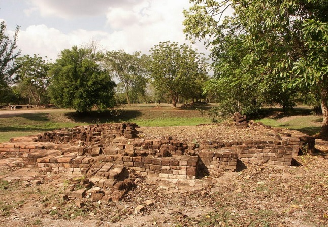
With this overview in mind, we set off to explore the monuments of the moated city, as meagre as we expected them to be. As it turned out there really was very little above ground level, with the ‘remains’ amounting to little more than several piles of bricks, most of them a mere a foot or so tall. There were mostly just the clay brick foundations of various religious structures. It was possibly to discern no more than their general dimensions, as all but the foundations had been lost. The largest of them, known as Monument 1, must have been an impressive structure in its day, as it measured 46 by 50 metres. It has been suggested that this was the vihara of a monastery. The second largest ruin was known as Monument 4 and it was probably the ubosot, where the monks performed certain rites. A short staircase was discernible at the front. There were also leaf-shaped bai sema, Buddhist boundary markers, outside this structure, which had helped archaeologists to guess its original function. Apart from these main two ruins, there was five more minor ruins scattered around the area, situated picturesquely in clearings in the trees and shrubs. These were much smaller in size, and are presumed to have been stupas on the grounds of the monastery. Some of them were square-based, and some of them were octagonal, but so scant are the remains that they barely rise above the grass and leaf -litter now. The site showed the value of doing some research in advance: If you hadn’t read something about Muang Sema beforehand, it would have been hard to make anything at all of the slight remains. Armed with an essay on the place from Stephen Murphy, we at least got some sense of a ruined monastery.
But if you want a more substantial reward for the trip out to Muang Sema, it is necessary to go outside the moat to Wat Phra Non, where easily the most impressive ruin in the vicinity can be found. Here, in a modern shed housing the antiquities, is the oldest reclining Buddha in all of Thailand. Believed to date back to the ninth century, it is fashioned of red sandstone and eleven metres in length. It is probably one of the most eye-catching monuments of the whole Dvaravati civilization, and it serves not only as the most compelling reason to come out to Muang Sema today but also as a reminder of the likely role that Muang Sema had played in the transmission of Buddhism to the Northeast of Thailand.
